LiDAR, short for Light Detection and Ranging, is a remote sensing technology utilizing laser light for highly precise distance measurements. It operates by emitting laser pulses towards a target, measuring the time it takes for the light to rebound. This process enables the creation of detailed and accurate 3D maps or models of the targeted area.
According to Future Market Insights the global LiDAR drone market reached a value of US$ 114.3 million, and it is projected to experience a remarkable Compound Annual Growth Rate (CAGR) of 19.8% from 2022 to 2032. The overall market size is expected to reach approximately US$ 892 million by the conclusion of 2032. LiDAR drones, along with their associated sensors, have the potential to generate significant cost savings across various sectors.
Multiplatform LiDAR systems refer to LiDAR setups that can be mounted on various platforms, such as airplanes, helicopters, ground vehicles, or even handheld devices. These systems are versatile and can be adapted to different applications and environments. LiDARit enables the digitization of outdoor, indoor, and underground environments from a variety of platforms.
LiDARit solutions
LiDARit offers an integrated system for drones, providing swift access and helicopters or manned aircraft for large extensions. This facilitates efficient data collection in areas that would otherwise be challenging to reach. You can also use it in vehicles or robots for indoor, underground, or spaces requiring frequent measurements. If an area is inaccessible to other modes of transportation LiDARit enables scanning while walking, allowing for meticulous data collection.
Below are three key uses for the payload:
- Point Cloud Extraction: You can use the LiDARit payload for infrastructure assessment by extracting detailed information from point clouds. This includes identifying and categorizing various elements such as road edges, traffic signs, power lines, poles, lighting fixtures, and road markings.
- Road Condition Monitoring: Classify cracks, bumps, and deformations in roads to assess their magnitude and precise locations, providing information for maintenance and safety measures. Regularly monitor embankment volumes and slope conditions to promptly detect any variations, ensuring terrain stability.
- Safety Compliance and Risk Mitigation: Implement weekly monitoring protocol to assess the minimum safety distances in undercuts, mitigating the risk of internal collapse.
Data Visualization and Collaborative Access
LiDARit bridges the gap between collected and analyzed data by incorporating artificial intelligence supervised by experts. The platform’s integration of data analysis and visualization tools, along with real-time collaborative access, maximizes the value of information. With collaborative features, you can team up and access scanned data online from any device, be it a laptop, mobile, or tablet, eliminating the need for other specialized software.
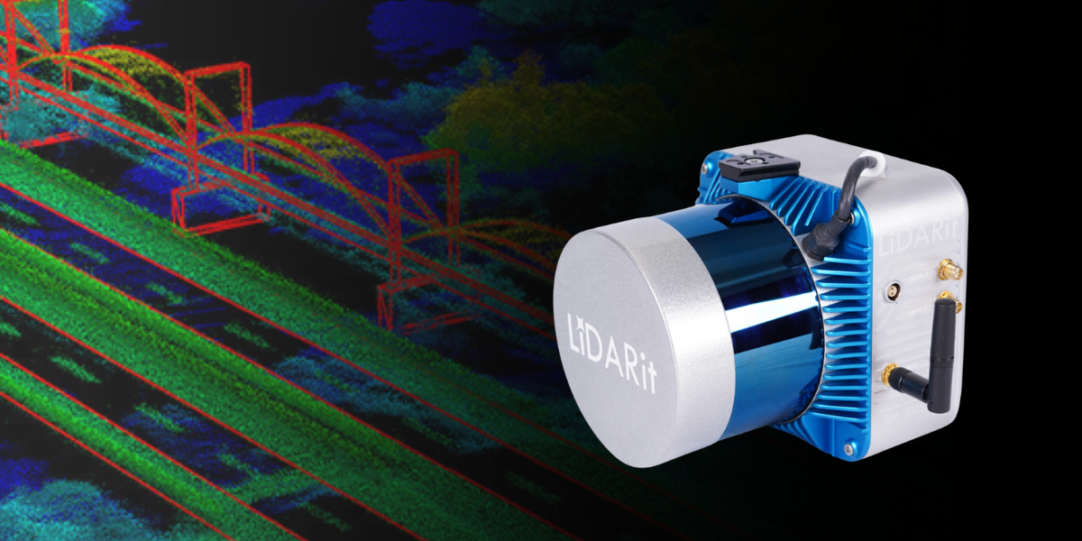
LiDARit Explorer R32
The Explorer R32 is the newest Multiplatform LiDARit solution developed for various industries, including Surveying & Mapping, Mining, Forestry, and Urban & Infrastructure. Encased in durable aluminum, the Explorer R32 has a maximum range reflectivity of 200 meters at 10% and has a high point density of up to 1.2 million points per second. With an IP65 rating, it guarantees protection against dust and water, making it a reliable choice for a range of professional applications. You can read more about LiDARit products here.
LIDARITMANAGER.AI
LiDARitManager.AI simplifies the analysis of LiDAR data. Operating on an High-Performance Computing cloud (HPC) service, it conducts post-processing to generate final land survey CAD drawings, products, and measurements. workflow begins with precise trajectory estimation using PPK GNSS-INS technology, ensuring trajectory or traverse closure errors are less than 8mm. Subsequent steps include accurate point cloud creation, adjustment for fluctuations between lines caused by blocked or unavailable satellite signals, point cloud classification, and the generation of various LiDAR deliverables. These deliverables have detailed terrain models (DTM), digital surface models (DSM), contour lines, orthophotos, land survey CAD drawings, stockpile measurements, and more, including requesting specialized documents tailored to your specific needs.
LiDARit has enhanced deliverables for many companies, providing detailed outputs for urban planning. In Peru, the LiDARit Explorer R surveyed a 15-kilometer railway track with 1-inch accuracy, showcasing its efficiency in precise location data for safe train operation. You can learn more about the difference between photogrammetry and LiDARs in our previous article “Comparing Photogrammetry and LiDAR for Advanced Geospatial Exploration” or connect with our experts for more information.


