
Mining operations are some of the most complex, high-cost, and high-risk activities throughout any industry, but they are an essential foundation for acquiring necessary resources. Leaders and professionals within the industry face several challenges—expensive equipment, safety risks, and lack of situational information that affect critical decisions. These challenges prevent mining companies from fully optimizing their operations and minimizing their capital costs.
Identify gas leaks, landslides, and other risks during inspection to reduce fatalities
However, drone technology is quickly becoming one of the preferred solutions to help alleviate the risk factors within the industry. By implementing drone technology, inspectors and surveyors can identify and map areas that are susceptible to landslips, gas leaks, and other risk factors that can lead to worker fatality. Because drones can be customized to a variety of needs with specialized sensors and payload technology, they are an ideal solution to the challenges faced by mining professionals.
Varying payload technology can be leveraged to tackle different industry problems. For example, specialized optical gas imaging (OGI) cameras and sensors, like those produced by Teledyne Flir, can be used to detect toxic gasses like methane and sulfur hexafluoride (which is often used to insulate electrical systems in underground mines). Inspectors can use drones with specialized payloads to investigate potential leaks without exposing themselves to explosions or toxic fumes.

Use advanced payload technology for critical operations.
Out of all the industries in the energy sector, mining has the highest fatality rate worldwide.
One of the leading causes of those fatalities is landslides, as supporting structures and areas can be weakened during excavation. By using drones equipped with smart mapping technology, mining surveyors can identify weak spots prior to excavation to decrease the likelihood of a landslide.
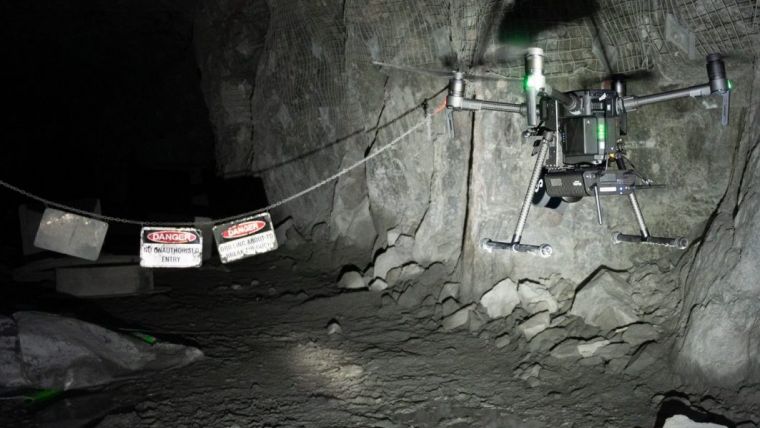
The latest advances in mining inspection and underground mapping come from Emesent’s Hovermap, a smart mobile scanning unit designed with incredible 3D LiDAR technology, used to collect data quickly and efficiently. Ideal for underground operation, the Hovermap was designed with SLAM-based (Simultaneous Localisation and Mapping) capabilities to function in areas that limit GPS flight. As a smart mobile scanning unit, the Hovermap can be fitted to a drone to provide autonomous mapping of difficult or inaccessible areas, such as caves, mines, or complex infrastructures. The benefit of this feature is simple—it allows drones to access areas that were once deemed unfit or unsafe for access for LiDAR mapping.
When drone-mounted, this unit combines the benefit of aerial data collection with Hovermap’s 360° virtual ellipsoidal shield technology. These unique capabilities prevent collision and maximize object avoidance in any environment, whether it’s underground, indoor, outdoor, day or night.
The Emesent Hovermap is unique in its ability to adapt to diverse environments for data collection in three different levels:
Autonomy Level 0— Mapping Mode:
Can be carried on a backpack or mounted to a drone or vehicle to provide SLAM-based mobile mapping.
Autonomy Level 1- Pilot Assist Mode
In this mode, the Hovermap has all of Level 0’s features plus LiDAR-based omnidirectional collision avoidance and velocity control in GPS-denied environments for safe flight indoors, underground, or close to structures.
Autonomy Level 2– Autonomous Waypoints Mode
At Level 2, the Hovermap maintains all of the previous features but also live-streams a 3D map of the surrounding areas during autonomous flight.
You can also implement the “Tap-to-Fly” feature to set smart waypoints on the live map.
The Hovermap is a popular payload for the DJI M300 RTK, as it helps underground drones navigate through tight, dark spaces even when GPS is unavailable. Mapping of underground stopes and other inaccessible or dangerous areas can happen in minutes, saving personnel and surveyors time and keeping them away from dangerous areas. Because of its lightweight design (4 lbs., or 1.8 kg), the Hovermap is also compatible with smaller drones, like the DJI M210.
Drones are an emerging technology adaptable to the multiple needs of the mining industry.
Drone Nerds has helped various mining institutions implement comprehensive drone programs into their operations—contact us to learn more about how we can help you today.