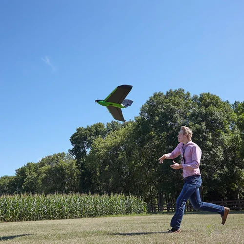
The PHX drone is a fixed-wing platform revolutionizing the drone industry and how it defines precision, reliability, and data accuracy.
SENTERA PHX DRONE
REMARKABLE PRECISION. DATA ACCURACY.
DESIGNED TO EMPOWER A NEW GENERATION OF DRONE PILOTS
Sentera remains at the forefront of drone sensor technology with its powerful solutions. From the advanced capabilities of the 6X and 65R sensors to the versatile PHX fixed-wing drone, Sentera empowers businesses across industries to enhance their missions. Learn more about its innovative solutions for agriculture, construction, environmental monitoring, and beyond.
HIGHLY-RELIABLE FIXED-WING DRONE
Get Access to Field Analytics and Insights to Run Your Business More Efficiently
The Sentera PHX is a fixed-wing drone designed to revolutionize data collection and analysis in agriculture, construction, environmental monitoring, and infrastructure sectors. With remarkable features such as a maximum flight time of 59 minutes, a weight of 4.5 lbs, RTK capability, and coverage of 640 acres per hour, the PHX offers unparalleled efficiency and precision in aerial data capture.
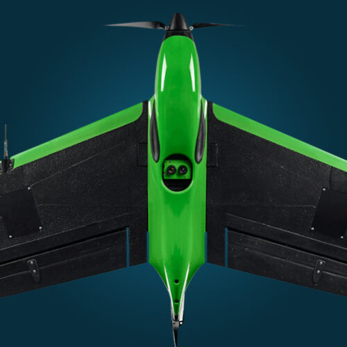
Sentera PHX
- 59-Min Max Flight Time
- Weight: 4.5 lb (2 kg)
- GSD: 3mm/px
- Accuracy: 3 cm
- Coverage: 640 ac/hr
- Plug-and-Play Integrations
SENTERA PHX APPLICATIONS
Purpose-build payload options allow you to perform stand count, weed detection and plant health analytics.
PHX is the only fixed-wing drone that maps stand counts and weed locations early in the growing season when action matters.
Analytics from Sentera FieldAgent® data analytics software generates accurate maps for making decisions at field-edge without an internet connection.
By using an omnidirectional, industrial-grade communications link, the PHX is designed to fly up to two miles away or more. This range is helpful for users with BVLOS (Beyond Visible Line of Sight) permissions and supports all users who stay within the typical one-mile VLOS (Visual Line of Sight) range.

With plug-and-play integrations with Sentera’s 65R, produce accurate digital surface models (DSMs) and imagery products for use cases in several industries:
- Agriculture
- Construction
- Environmental Monitoring
- Infrastructure
UNLOCKING EFFICIENCY
With plug-and-play integrations with Sentera’s 6X and 65R, produce accurate digital surface models (DSMs) and imagery products for use cases in several industries.
The 6X Multispectral and 6X Thermal are lightweight single-camera solutions that offer synchronized capture of radiometric-accurate multispectral, thermal and high-resolution RGB imagery.
The 65R Sensor is the first high-resolution aerial RGB sensor in its class to deliver seamless drone integration without compromising image quality. With a sustained 3 Hz capture rate of 65-megapixel global shutter imagery, the 65R produces exceptional visual-band imagery.
These sensors are equipped with an ample 512GB of high-speed internal solid-state storage, high capture rate, and gimbal stabilization, enabling longer flights, covering more area.
ENHANCED DATA COLLECTION
With the PHX, capture high-resolution aerial imagery for insights into your field. Go deeper with our analytics, which translate imagery into detailed data sets, helping you make critical in-season decisions about key inputs based on identified outcomes.
- Canopy Cover
- Crop Area
- Crop Health
- Flowering
- Residue Cover
- Stand Count
- Tassel Count