Interior and exterior visual data from any altitude and any angle – all in one platform.
DroneDeploy
WORK SMARTER WITH DRONE MAPPING SOFTWARE
DELIVERING
Powerful Digital Reconstruction & Visual Records
DroneDeploy software is platform agnostic. Create highly precise mapping and 3D imagery with almost any unmanned aircraft that relies on GPS for positioning. DroneDeploy turns any compatible drone into 3D imaging machine. Gather data and see 2D maps live that convert to 3D easily with just a few clicks. When you save data with DroneDeploy, you also save money and effort.
DroneDeploy Serves Multiple Enterprises:
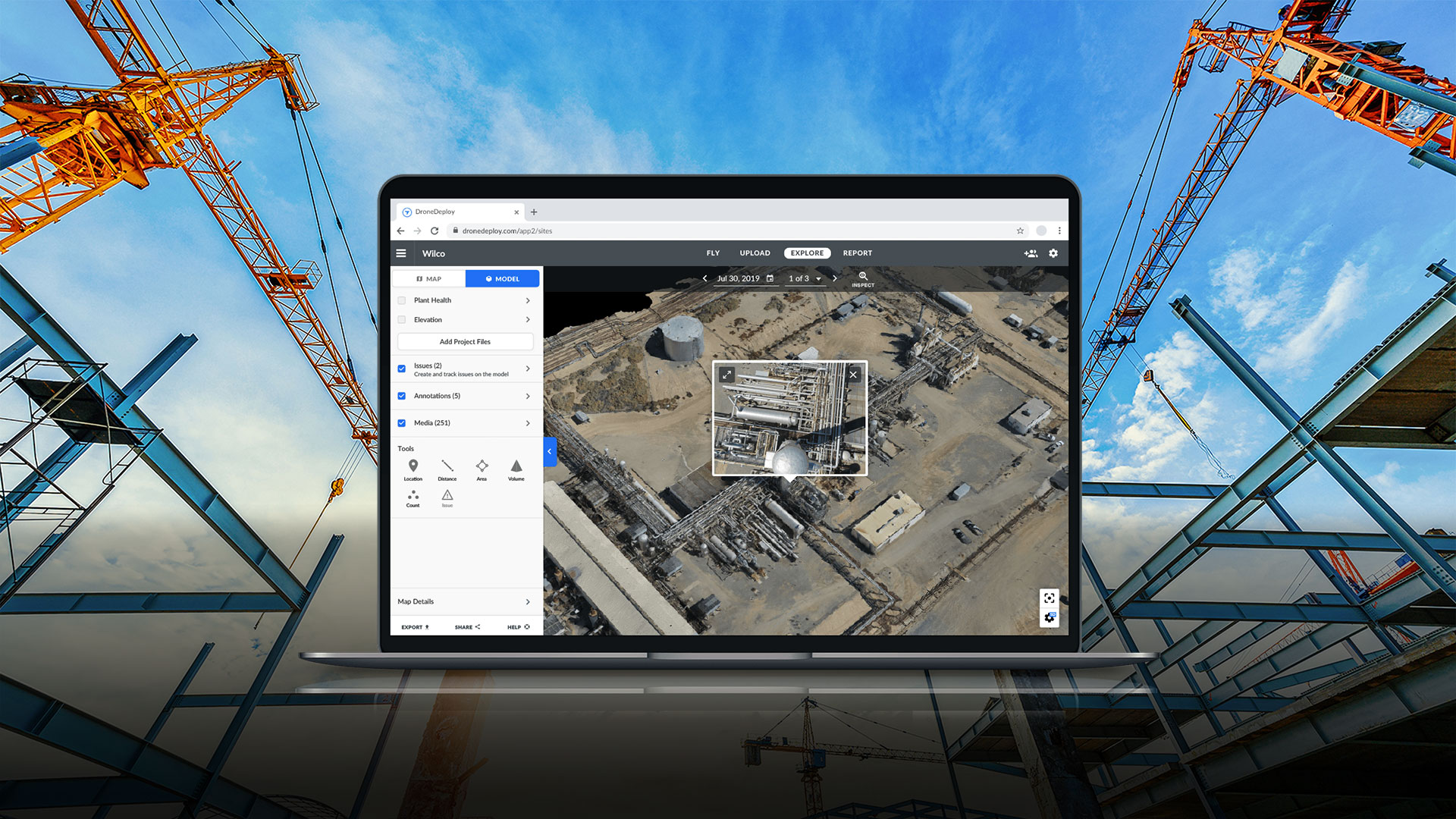
Construction
Whether you’re an engineering firm conducting precision surveys or a contractor keeping tabs on the progress of commercial or residential projects, DroneDeploy saves time and increases accuracy.
Real Estate
Real estate developers can easily map and monitor projects, and share data with investors, contractors, and third parties.
Ready for listing? Real estate brokers can create 3D walk-throughs for faster listing times.
Inspection
Insurance adjusters can inspect and assess damages quickly and safely, improving claim processing times.
DroneDeploy allows inspectors view and record remote assets with heightened safety for workers.
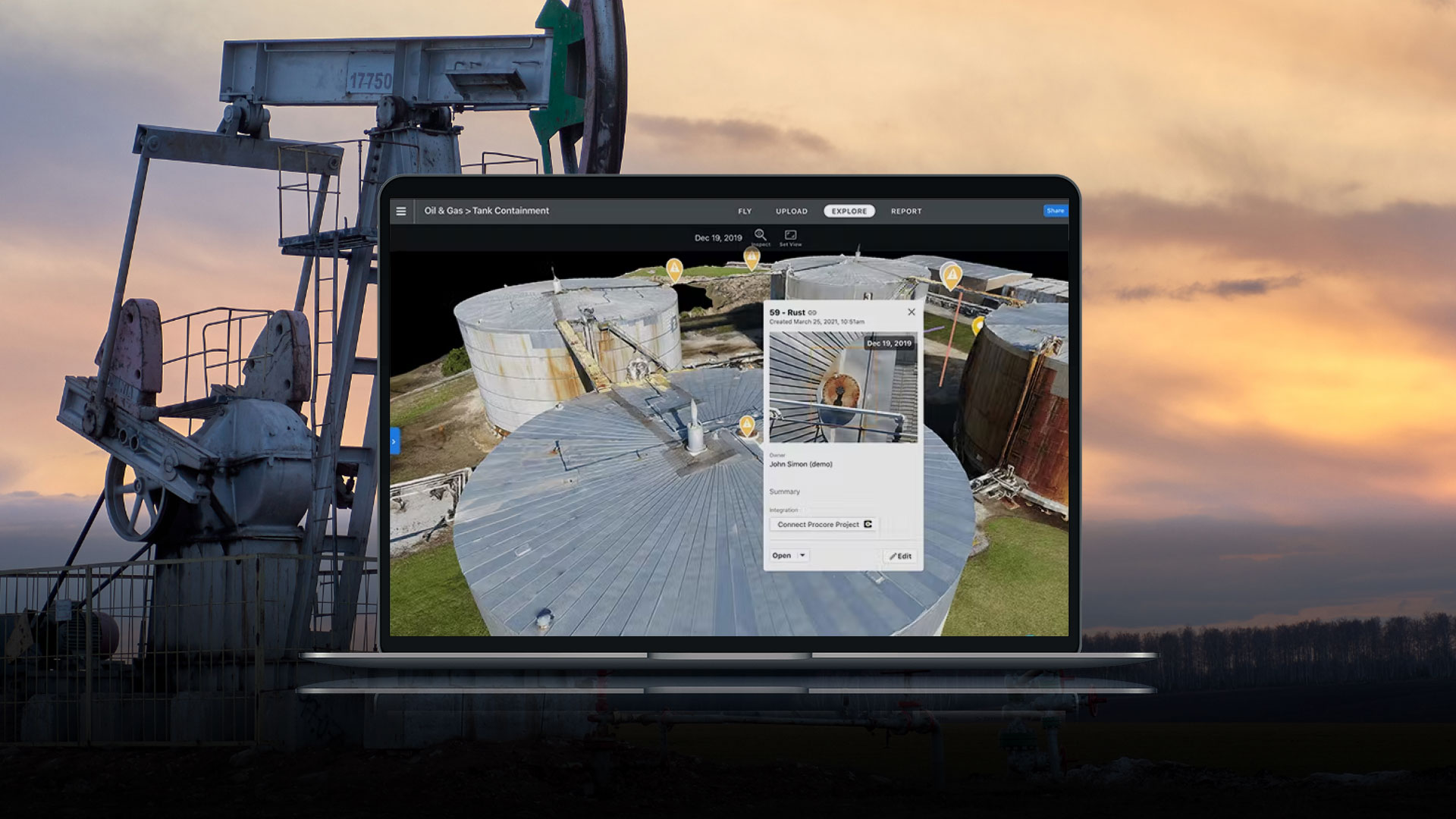
Oil & Gas
Manage operations at scale with digital replicas of sites and assets, helping engineers and field teams access accurate data in real-time.
Agriculture
Support precision farming by mapping fields in minutes. Conduct crop analysis, identify variability, and make in-field recommendations with just a few clicks.
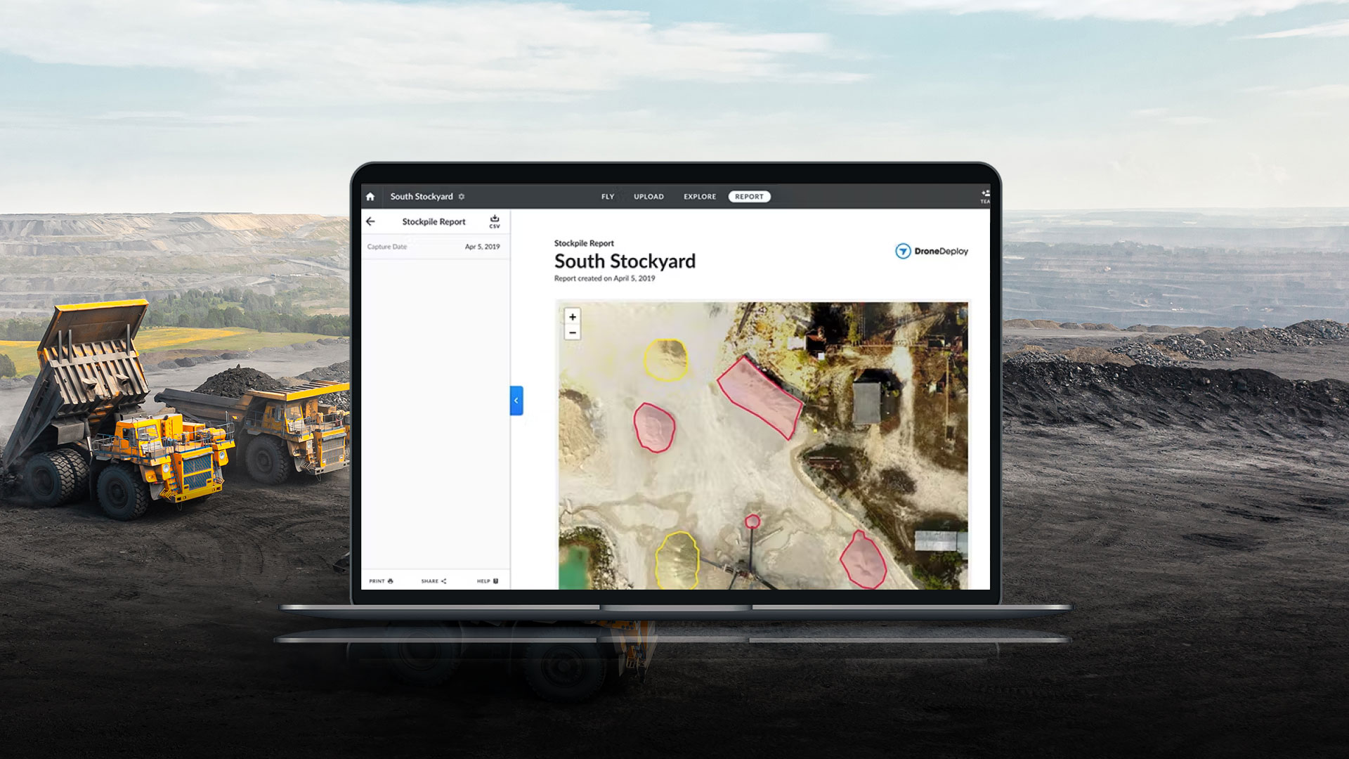
Mining
Make planning and fulfillment decisions quickly and measure stockpiles more often for a fraction of the cost of traditional methods.
DroneDeploy features an audit-friendly hub for easy reporting and asset management.
DroneDeploy Advantages
Collaboration
Drone Deploy makes it easy for teams to coordinate operations, even if they’re using multiple platforms.
Easy Data Access
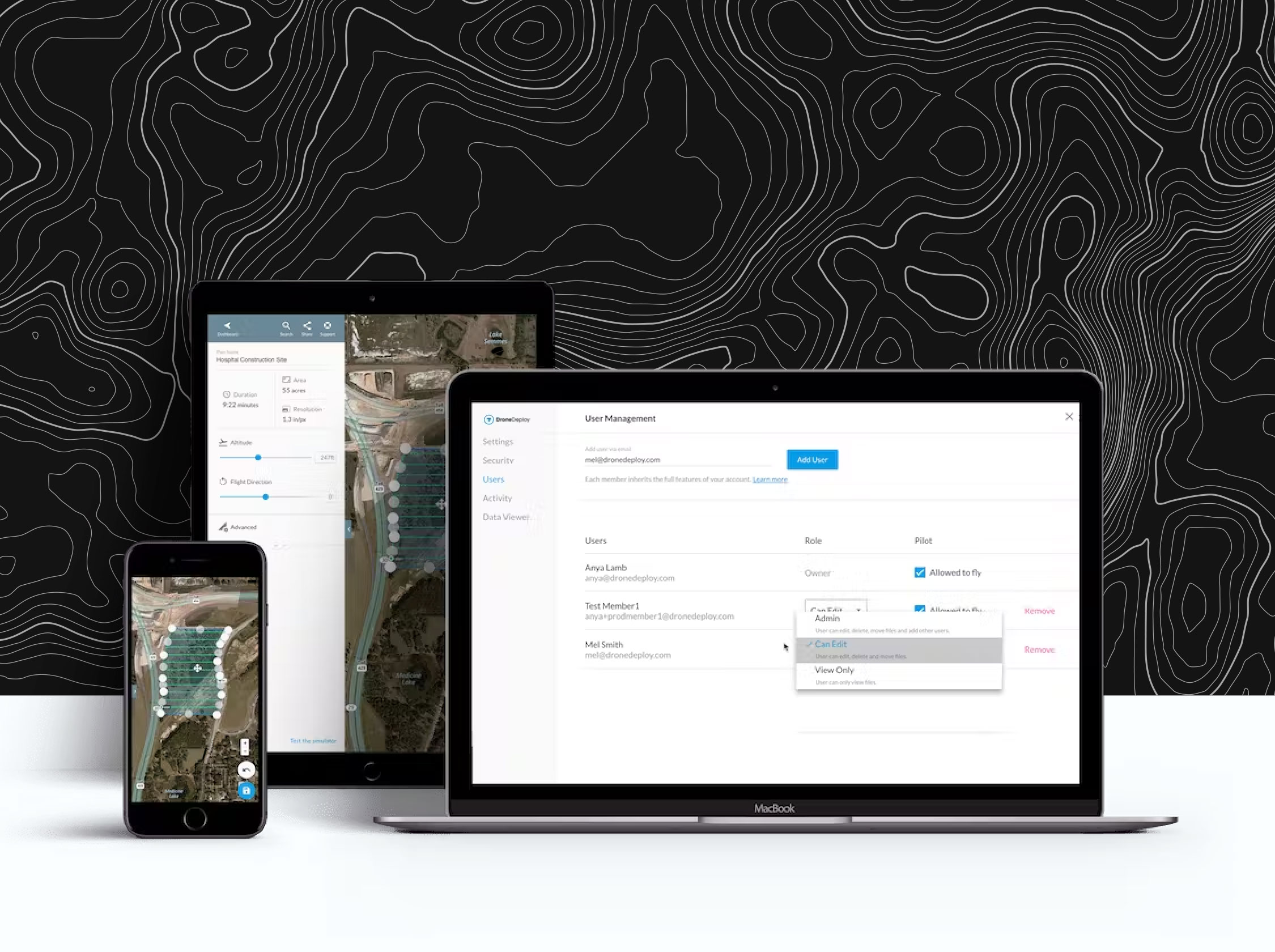
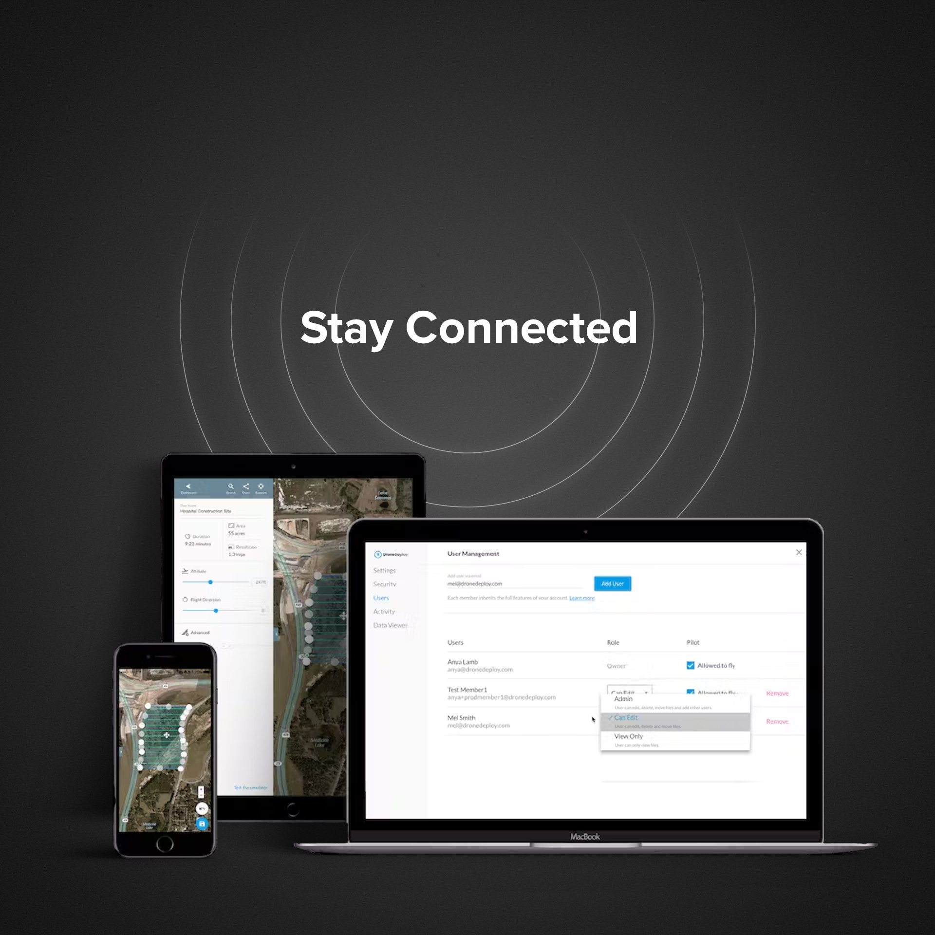
Get fingertip access to data, maps, analysis and flight records, including precisely where and when multiple aircraft were flown.
Management
Manage pilots, teams, flights and aircraft from the platform’s Admin Panel for improved efficiency.
Data Security
Allow password-enabled data sharing with user roles that share within parameters or even limit users to one-time access.
Supported Drones
DroneDeploy's flight and walkthrough apps support some of the best commercial hardware on the market for customers in agriculture, construction, oil & gas, solar, mining, and more. See the complete list of supported drones for flight and 360 cameras for walkthroughs.
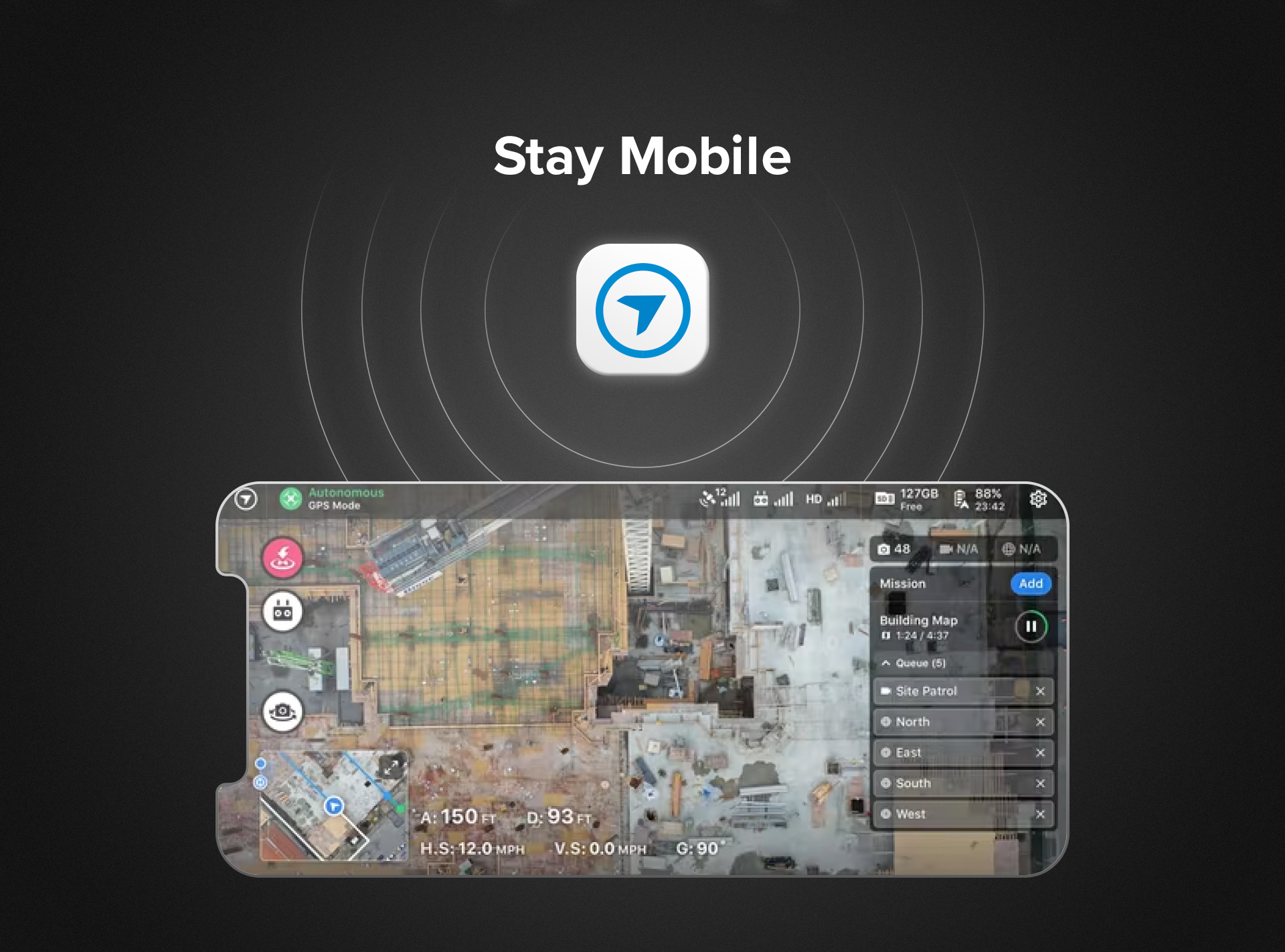
View Data Anytime, Anywhere
DroneDeploy is ready to work with any drone equipped with GPS capability. Download DroneDeploy to a mobile device for easy mapping—select the flight area and watch as your drone maneuvers through waypoints, gathering data along the way.
Measure distance, area, or volume with geo-tagged imagery and track changes in conditions, such as construction progress over time.
Build maps illustrating plant and growing field health. Measure buildings or roofs, and distances between any points on the map.
Accessible, Actionable Data
Upload collected data to DroneDeploy through a wireless connection, cable, or microSD card. DroneDeploy offers several export options so you can use data across other programs, like Autodesk, Airmap, Climate Field View, John Deere, Scopito, EZ Roof, and many more.
View DroneDeploy imagery and data on any device and share with colleagues, partners, or stakeholders at the click of a button.
DroneDeploy Applications
Map fields in minutes to conduct stand counts, identify variability, and make in-field recommendations, all offline at the field's edge.
Demonstrate product performance across research and development, production, and commercial teams with field-edge mapping, multispectral processing, and automated stand counts. Reduce travel to the field by live streaming drone footage to teams around the world.

Through aerial maps, 3D models, and key integrations, DroneDeploy automates analysis and reporting to speed up site and asset inspections, reduce direct risk to workers, and improve communication between teams.
Conduct asset inspections remotely with automated data collection for maps, 3D models, and vertical structures. Collaborate with teammates using annotations and measurements to ensure issues are closed out and assets are compliant with regulations.
Keep employees safely on the ground with a remote inspection workflow. Document site conditions to prepare teams for emergency response, and prioritize response teams if a disaster were to occur.
Speed up site surveys for new locations and document the entire construction process with elevation maps, models, videos, and panoramas. Maintain up to date site data within your system of record using our out-of-the-box Esri integration.
With DroneDeploy, give your entire team access to visual documentation of every stage of the project, from pursuit and bid to groundbreak through ribbon-cutting.
Save time, improve communication, and reduce cost by using aerial and ground data to perform surveys, conduct inspections, and document every job site. Bringing full site documentation into one solution, DroneDeploy enables you to capture interior, exterior, ground, and aerial data. Through a digital twin of your job site and in-depth analysis, projects run on time, on budget, and safely.
Improve Your Inspection Workflow With A Complete Site Reality Solution
Traditional, manual Inspections on a property or project can cause disruption and puts workers at risk. Using site reality solutions such as drones, 360 cameras, and ground robotics improves safety, streamlines the inspection workflow, and allows teams to collaborate more quickly to take immediate action on issues and progress reporting. See how teams are leveraging DroneDeploy for Inspection in Construction and Energy

Quickly and safely manage your portfolio with DroneDeploy Roof Reporting Insights.
Automatically collect high resolution roof imagery and generate comprehensive roof reports 3x faster than traditional methods.

Use aerial data to increase efficiency and accuracy of stockpile management, inspections, and excavation while keeping your team safe and compliant
Make planning and fulfillment decisions with more accurate, timely information to avoid waste and recognize revenue faster
- Measure stockpiles more often for a fraction of the cost of traditional methods
- One easy-to-use, audit-friendly hub for all stockpile volume measurements
- Report the total quantity and value of materials on site
- Export all drone data easily to your system of record
Through aerial maps and 3D models, DroneDeploy automates analysis and reporting to speed up the site survey process, standardize the deliverables, reduce direct risk to workers conducting inspections, and improve collaboration with stakeholders.
Speed up the site selection and planning process for utility and residential solar projects by standardizing the deliverable for ground surveys or roof panel designs. Increase the ROI for renewable projects by streamlining the site assessment process.
Oversee subcontractor work with real-time drone data and improve transparency and collaboration with stakeholders using a variety of media types and reports. Decrease the number of platforms needed for project management, surveys, and documentation.
Reduce direct risk to workers conducting roof inspections or ground surveys while complying with stringent, changing government regulations. Detect damage and maintenance problems while maintaining photographic evidence for insurance claims.
