MicaSense Sensors
Agricultural Sensors
Drone Sensors for Vegetation Mapping
MicaSense drone sensors help growers, land managers, and researchers use drone-based imagery to make informed decisions. They adapt easily to many drones for efficient crop scouting, agricultural mapping, field moisture evaluation and other ag-related measurements.
Who Benefits from MicaSense Sensors:
- Farmers, from small, family-owned operations to large-scale corporations
- Agronomists, scientists, and researchers
- Crop scouting services and insurance adjusters
- Scientists and researchers
- Seed companies needing to monitor test fields
- Inspectors of hard-to-access infrastructure
Agriculture professionals, from farmers to scientists, and researchers, use MicaSense sensors mounted to unmanned aerial vehicles to gather field and crop data. MicaSense products mount easily with integration kits, so the choice of drones is wide. Agriculture professionals rely on computer-aided analysis of data to detect crop disease, crop stress, field moisture conditions, weed populations, and other factors.
Micasense Sensors Advantages
Comprehensive data enables farmers to determine and take prompt action to eliminate problems, maximizing yield.
Early Detection
All MicaSense sensors read five bands of light—blue, green, red, red edge, and near-infrared, or NIR. Red edge data promotes early detection of crop disease and stress for quick action to correct deficiencies in a whole field or a targeted portion of the field.
Harvest Your Data
MicaSense sensors can harvest data from 160 acres in just 27 minutes. Data can be accessed and analyzed at field’s edge, stored, and retrieved for more detailed analysis and crop-saving action.
Reliable Comparisons
All include the MicaSense DLS for advanced light calibration and GPS for precise placement, making comparisons over time highly reliable.
CASE STUDIES
Partners around the world share their experiences and results with the MicaSense drone sensors.
RedEdge-P DUAL
The Rededge-P DUAL is a high-resolution multispectral and RGB composite drone sensor for plants classification, weeds identification, environmental research and conservation, and vegetation analysis of water bodies.
The dual solution features the RedEdge-P and the new RedEdge-P blue cameras.
The RedEdge-P DUAL is compatible with the DJI Matrice 300 drone. The camera features an open API interface for easy integration with most flight planning and post-processing software, including Measure Ground Control.
RedEdge-P
The RedEdge-P is the rugged, high-quality, powerful multispectral sensor you’ve come to trust, now with a high-resolution panchromatic band for pan-sharpened output resolutions of 2cm (at 60m) – twice the ground resolution of the industry-standard RedEdge-MX.
It is a single camera solution that captures calibrated high-resolution multispectral and RGB imagery, with an optimized FOV and capture rate for efficient flights.
This solution seamlessly integrates a high-resolution all-color imager with synchronized multispectral imagers to enable pixel-aligned outputs at previously unattainable resolutions while maintaining the efficiency and reliability of the RedEdge legacy.
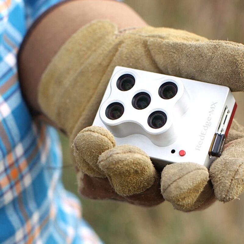
RedEdge-M
Even the RedEdge-M, the most economical of the MicaSense line of agricultural sensors, gathers data from five light bands. Extreme efficiency results from its ability to assemble multiple data sets from intelligence gathered on a single flight.
RedEdge-M, despite holding five cameras, is small, lightweight, and adaptable to many aircraft. And it’s rugged, so it will hold up over years of service.
Layered data sets provide a sharper focus of where field or crop problems lie, leading to fast analysis and prompt, yield-protecting corrective action.
Altum
A FLIR thermal imaging camera augments the five cameras recording RGB data and intelligence from other narrow light bands. Each Altum camera has a higher-resolution sensor for exceptional image clarity.
On a single RedEdge Altum flight, planned in detail before takeoff and executed with minimal additional input, data is collected from five light bands plus the infrared band of the spectrum. Infrared imaging makes the Altum useful not only in crop scouting, but also in infrastructure inspection work.
Generate NDVI and NDRE analyses, and thermal heat maps to detect drainage issues, and crop disease and stress. To accommodate its higher resolution and infrared capabilities, Altum has expanded storage.
A DJI Skyport-compatible version makes it easy to command not only the aircraft but also the sensor with the DJI remote controller.
Unparalleled Operational Efficiency
MicaSense sensors offer one-pass efficiency, collecting and outputting multiple data sets. They enable users to generate visual analytics for quick and precise yield-preserving action.

Visuals include:
- A chlorophyll map, which is key to understanding vigor and health in the early stages of plant growth;
- NDVI, a widely used reference of field health;
- A Digital Surface Model, which agronomists, consultants, and researchers use to understand topography and its effect on water retention and runoff;
- And an RGB image, made sharp by a global shutter that prevents the rolling distortion that’s common with drone cameras.
Visuals can be superimposed to more precisely target corrective action, cutting chemical costs and reducing application time. The thermal imaging delivered by the Altum sensor adds more detailed data by measuring temperature differences in parts of a field and over time.
Versatile Analytics
RedEdge and Altum sensors are compatible not only with available MicaSense Atlas cloud-based analytics, but also with a wide range of platforms. As a MicaSense sensor operator, you’ll have the option of using a software platform that you already have, or choosing the platform that best suits the job or a client’s needs.
Collaboration by MicaSense and DJI makes analysis with DJI’s Pix4Dfields and Pix4Dmapper software especially simple—and highly effective. Skypoint compatibility kits and drone integration kits for MicaSense products are available.